


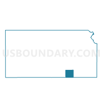
Maple Township Voting District, Cowley County, Kansas
About
Outline

Summary
| Unique Area Identifier | 584341 |
| Name | Maple Township Voting District |
| County | Cowley County |
| State | Kansas |
| Area (square miles) | 35.10 |
| Land Area (square miles) | 35.10 |
| Water Area (square miles) | 0.00 |
| % of Land Area | 99.99 |
| % of Water Area | 0.01 |
| Latitude of the Internal Point | 37.43320820 |
| Longtitude of the Internal Point | -97.09559580 |
Maps


Graphs
Select a template below for downloading or customizing gragh for Maple Township Voting District, Cowley County, Kansas


Neighbors
Neighoring Voting District (by Name) Neighboring Voting District on the Map
- Douglass Township/City Voting District, Butler County, KS
- Fairview Township Voting District, Cowley County, KS
- Gore Township Voting District, Sumner County, KS
- Ninnescah Township Voting District, Cowley County, KS
- Richland Township H78 Voting District, Butler County, KS
- Rock Township Voting District, Cowley County, KS
- Rockford Precinct 03, Sedgwick County, KS
Top 10 Neighboring County Subdivision (by Population) Neighboring County Subdivision on the Map
- Rockford township, Sedgwick County, KS (22,784)
- Richland township, Butler County, KS (2,568)
- Douglass township, Butler County, KS (2,171)
- Gore township, Sumner County, KS (2,105)
- Ninnescah township, Cowley County, KS (1,050)
- Maple township, Cowley County, KS (716)
- Fairview township, Cowley County, KS (248)
- Rock Creek township, Cowley County, KS (243)
Top 10 Neighboring Place (by Population) Neighboring Place on the Map
Top 10 Neighboring Unified School District (by Population) Neighboring Unified School District on the Map
- Mulvane Unified School District 263, KS (10,019)
- Rose Hill Public Schools Unified School District 394, KS (7,986)
- Douglass Public Schools Unified School District 396, KS (3,540)
- Udall Unified School District 463, KS (2,026)
Top 10 Neighboring State Legislative District Lower Chamber (by Population) Neighboring State Legislative District Lower Chamber on the Map
- State House District 81, KS (23,242)
- State House District 77, KS (22,516)
- State House District 78, KS (20,447)
Top 10 Neighboring State Legislative District Upper Chamber (by Population) Neighboring State Legislative District Upper Chamber on the Map
Top 10 Neighboring 111th Congressional District (by Population) Neighboring 111th Congressional District on the Map
Top 10 Neighboring Census Tract (by Population) Neighboring Census Tract on the Map
- Census Tract 99, Sedgwick County, KS (10,159)
- Census Tract 9621, Sumner County, KS (5,271)
- Census Tract 209.03, Butler County, KS (3,652)
- Census Tract 4932, Cowley County, KS (3,066)